Monday, December 8, 2014

New Mexico's Geologic Future


New Mexico's geography is marked by some stark, striking symmetries. Bisected almost perfectly down the middle by the Rocky Mountains, and a little less perfectly by the Rio Grande River, New Mexico is a land cut up by veins and webs of geographic and cultural importance. Not surprisingly, the Rocky Mountains are not one big mountain range, but two distinct and nearly perfectly parallel smaller ones, the Jemez mountains in the west, and the San Juan in the east. No matter whether in The Great Plains in state's easternmost third, the jagged volcanic landforms of the northern Great Plains, or the High Plains that run along the New Mexico-Texas border, everywhere you go will be completely, totally arid and dry.

In 10,000 years...
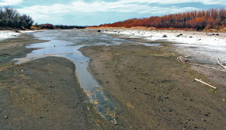
The physical geographic formations that mark New Mexico will not have changed much. 10,000 years will likely not be enough time for volcanism in the Rio Grande Rift to reactivate, as the last period of recorded volcanic activity will have ended just under a million years earlier. As global temperatures are expected to continue rapidly rising, droughts will worsen and appear with increasingly greater frequency. If the Rio Grande is more than 50% evaporated now, and the Pecos River about 15% evaporated now, by this point these rivers will like have dried up completely, stopping any and all hydrological erosional processes.

In 1,000,000 years...
Volcanism along the Rio Grande Rift will have been reactivated. As the movement along this normal fault heats up, the valley that is now home to the Rio Grande River (but will then likely be a completely dried-up valley) will continue to sink. The mountain ranges on both sides of this valley, the Jemez and San Juan, will continue their uplift.

In 100,000,000 years...
By this point in geologic time, tectonic plate movement will have progressed to the point of literally tearing what is now the United States in half through the South and Midwest.

Thursday, November 13, 2014

Climate Change in New Mexico

Climate change may be affecting no area of the United States more harshly than it is the Southwest, and apparently, as the title of one in-depth Los Angeles Times feature story boldly proclaims, "New Mexico is the driest of the dry."

drying portion of the Rio Grande River, outside of Santa Fe, NM

New Mexico's climate was formally classified as semi-arid to arid to begin with, but now the entire state is in the middle of a drought of unprecedented severity. 2010-2013 were the hottest, driest years since 1985, when climate record-keeping first began. But even outside of the records, photographic as well as anecdotal info (many families have along the Rio Grande for generations) show that the river is at its lowest ever. At points, it does not resemble a river at all, but rather a sandy bank graced by the odd puddle.

A rancher surveying what is left of his federal allotment land

These changes are probably due to a combination of factors both human and environmental. As animal agriculture spread west with everything else, farmers thought they could keep using the same farming style that was suitable for more humid climates, such as those in the midwest. Cattle can graze a piece of land in New Mexico until it is stripped completely clean of its vegetation, causing the ground to be more directly exposed and susceptible to groundwater loss through evaporation. Human consumption of water has placed a heavy toll the water, as well. On top of it all, over 95% of the state has experienced increases in mean temperatures in the last three years, which could be symptoms of another problem, man-made climate change.

Climatograph of Albuquerque, NM. Indicative of "BWh" or subtropical desert climate.

New Mexico is completely landlocked. Due to this "continentality," as well as its relatively complete lack of humidity, temperatures shift can shift drastically throughout the day. New Mexico's climate could be accurately given the more accurate label of "subtropical desert," abbreviated for the Koppen climate classification as "BWh."

Sources:
http://earthobservatory.nasa.gov/Features/NAmerDrought/NAmer_drought_2.php
http://www.latimes.com/nation/la-me-parched-20130806-dto-htmlstory.html
http://www.nature.org/ourinitiatives/regions/northamerica/unitedstates/newmexico/new-mexico-climate-change.xml
http://nmsierraclub.org/climate-change-affect-New-Mexico

Photo Credits:
http://www.santafenewmexican.com/news/local_news/new-mexico-grapples-with-tough-choices-amid-drought/article_36bbe242-e83f-5190-97cd-9427521a6675.html
http://www.nmnewsandviews.com/2011/08/02/drought-devastating-new-mexico-ranchers/
http://drought.unl.edu/archive/climographs/AlbuquerqueMetric.htm

Monday, October 13, 2014

The Rio Grande Rift

The Rio Grande Rift runs right through the middle of New Mexico...right under, or along, the Rio Grande River.

Rio Grande River, Fort Selden NM

Many wrongly assume that the Rio Grande Rift was created by the Rio Grande River via erosional processes. It's actually the opposite. It began forming around 35 million years ago via normal faulting and extension in the Earth's crust. The result of these processes was a series of four large, semi-connected basins which would eventually fill up with water flowing downhill into the rift, then forming the river.

Generalized Cross Section of the Rio Grande Rift

Volcanoes, as well as landscapes and landforms shaped and formed by them, are plenty in New Mexico. Because New Mexico receives so little rainfall each year (a mere 15 inches compared to the national average of 37), volcanic landforms have eroded very little in the time since their formation. For this reason, combined with the fact that most wild areas in New Mexico are covered in just low-lying grasses, volcanic landforms have been very easy for geologists to spot and catalogue.

Although there hasn't been much volcanic activity at all in recent history, the Rio Grande Rift was once the site of intense volcanism. Yet, only 1.2 million years ago (not a lot in geologic time), The Valles Caldera, one of the world's youngest and largest (13.7 miles wide!) calderas, was created by the collapse of a magma chamber, triggered by an eruption on the scale of what geologists would classify as a "supervolcano."

Satellite Image of Valles Caldera

About 15 million years into its formation, the rift's basins began to open, exposing tons of mafic, (obviously extrusive) igneous rock, such as basalt.

Something I found very interesting is that geologists believe the rift region to be "dormant" and not "extinct," meaning that at some point in geologic time, there are likely to be major volcanic events in New Mexico.

Sources:
http://academic.emporia.edu/aberjame/student/reardon3/RIFT%20NEW2.html
http://en.wikipedia.org/wiki/Valles_Caldera
http://cires.colorado.edu/science/groups/sheehan/projects/riogrande/faq/
http://aconcagua.geol.usu.edu/~arlowry/RGR/faq.html

Photo Credits: 
http://newswatch.nationalgeographic.com/2014/07/03/along-the-rio-grande-an-innovative-water-market-restores-riverside-habitat/
http://en.wikipedia.org/wiki/Rio_Grande_rift#mediaviewer/File:Riogranderift_deepXsection.png
http://upload.wikimedia.org/wikipedia/commons/0/04/Valle_Caldera,_New_Mexico.jpg

Tuesday, September 16, 2014

New Mexico's (Enchanted!) Mountainous Landscapes

New Mexico is located in North America, in the Southwestern portion of the United States. It is bordered by Colorado on the north and Texas and Mexico to the South. To the west, Arizona; to the east, Texas and Oklahoma. Its capital, Albuquerque, is located roughly at 35° N and 106° W.

geographic map of New Mexico
Central New Mexico's landscape is dominated by the towering peaks of the Rocky Mountains. Cutting vertically across North America, reaching as far north as British Columbia, they find their southernmost base near the New Mexico-Texas border. The Rio Grande River, New Mexico's most important and definitive aquatic feature, winds down through the Rockies, flowing from North to South.

Much of eastern New Mexico is covered by the Great Plains, which extend down from the foothills and High Plains of the Sangre de Cristo mountain range. In this area, the Pecos River and its tributaries have worn deep valleys and canyons into the earth.

New Mexico's Great Plains
The Basin and Range Region of New Mexico, marked by its stark, jagged mountain ranges (Organ, San Andreas, Guadalupe...), disjointed by desert basins. Beginning in northern New Mexico, near Santa Fe and Rio Rancho, this region spreads southwest into Arizona and Mexico.

La Jencia Grasslands & Magdalena Mountains
New Mexico's highest natural peak is Wheeler Peak, located northeast of Taos, in the Sangre De Cristo's, the Rocky Mountain's southmost subrange. It lies at a peak elevation of 13,167 ft. which, for perspective, is just over a thousand feet lower than Mt. Elbert, Colorado's highest peak, which lies at an elevation of 14,440 ft. New Mexico, therefore, is home to no "fourteeners."

Wheeler Peak, viewed from Eagle Nest
Photo Credits:
http://www.netstate.com/states/maps/nm_maps.htm
http://www.tfrec.wsu.edu/pages/web4/blog/5037
http://northernwingsbirder.blogspot.com/2010_12_01_archive.html
http://en.wikipedia.org/wiki/Wheeler_Peak_(New_Mexico)

Sources:
http://www.infoplease.com/encyclopedia/us/new-mexico-geography.html
http://www.mapsofworld.com/usa/states/new-mexico/geography.html
http://www.summitpost.org/wheeler-peak-nm/150429

Wednesday, September 3, 2014

Blog Introduction

My name is Karim Kazemi. This is my blog about the geography of New Mexico.

Ram's Head With Hollyhock by Georgia O'Keefe, set against the Sandia Mountains 

I've picked New Mexico to use as my geographical location for this blog. New Mexico is a pretty important place to me. It's where my mom is from, where my parents met, where I was born (and maybe conceived...?), and it's where a lot of my ancestors laid down roots when they came to America. My dad's family moved there in the 1970's, and my mom is descended from Spanish missionaries who settled around Albuquerque in the 1700s. Aside from being where my a lot of my family lives, it's also one of my favorite places to travel around/explore. I have some pretty specific tastes when it comes to what kinds of weather/climates I find enjoyable (I can't stand humidity, overly cold winters, etc), and New Mexico satisfies pretty much all of them. It sounds a little goofy, but I feel an almost "spiritual" connection to the landscapes and open spaces of New Mexico, far more so than those (admittedly beautiful) ones here in Colorado, where I grew up.

Santa Fe at night

New Mexico is home to tons of unique geographical formations and features. Over the course of this semester I hope to gain knowledge of the many processes and geographic systems that have shaped such special and numinous landscapes.

Bandelier Overlook, Bandelier National Monument, Sandoval County, NM

Photo Credits:
http://www.georgiaokeeffe.net/ram-head-with-hollyhock.jsp
http://activerain.trulia.com/blogsview/2239151/starry-night-the-neighborhoods-of-santa-fe--new-mexico--87501
http://www.visitusa.com/newmexico/